Skip to Content
Camping ReservationsCareersContact UsDonate Now

Saugeen Valley Conservation Authority Logo

Contact Us
  • Outdoors and Recreation
    View our Outdoors and Recreation page
    • Camping
      • Durham Winter Camping
      • Reserve a Campsite
      • Group Camping
      • Firewood
      • Rules and Regulations
    • Activities and Recreation
      • Canoeing and Kayaking
      • Day Use Fees
      • Durham Disc Golf
      • Fishing
      • Hunting
      • Rent a Facility
      • Trails and Hiking
      • Saugeen Bluffs Events
      • Winter Camping at Durham CA
    • Outdoor Spaces
      • Allan Park
      • Bell's Lake
      • Brucedale
      • Denny's Dam
      • Durham
      • Hardwood Hill
      • Kinghurst
      • McBeath
      • Mildmay-Carrick
      • Saugeen Bluffs
      • Schmidt Lake
      • Stoney Island
      • Sulphur Spring
      • Varney
  • Permits and
    Planning
    View our Permits and Planning page
    • Appeal Process
    • Applying for a Permit
    • Book a Planning Act Pre-Submission Consultation
    • Environmental Regulations
    • Maps and GIS
    • Agreements
    • Planning and Regulations FAQ
    • Planning Services
    • Report a Concern
  • Forestry and
    Landowner Services
    View our Forestry and Landowner Services page
    • Forestry and Land Management
    • Stewardship Projects and Services
    • Tree Planting and Sales
  • Water Management
    and Protection
    View our Water Management and Protection page
    • Drinking Water Source Protection
    • Flood Forecasting and Warning
    • Frequently Asked Questions
    • Water Quality Monitoring
    • Water Well Improvement Program
    • Watershed Report Cards
    • Water and Climate Data
    • Water and Erosion Control Infrastructure
  • About
    Us
    View our About Us page
    • Accessibility and Customer Service Standards
    • Board of Directors
    • Careers
    • Committees
    • Contact Us
    • Delegation Request
    • Donate Now
    • Explore SVCA Program
    • Freedom of Information
    • Governance
    • Hours and Location
    • Meeting Calendar
    • Meeting Summaries
    • News and Notices
    • Subscribe
    • Tenders and RFPs
x

Surface Water Quality

  • Facebook
  • Twitter
  • LinkedIn
  • Email

Surface water is monitored at 31 sites along major streams and rivers in our watershed.  This monitoring happens through the Provincial Water Quality Monitoring Network (PWQMN) and through Saugeen Conservation's own network.  Sampling occurs monthly from April to November each year.  Surface water quality for this report was graded on phosphorus, Escherichia coli (E.coli), and benthic macroinvertebrates.

Phosphorus is an essential nutrient for all living organisms, however it can have harmful effects on aquatic life at high levels. Phosphorus levels can be natural, and increase with human influence.

E.coli is a type of bacteria commonly found in the intestines of warm blooded animals. E. coli is often used as an indicator of contamination from human and animal waste. E.coli levels may increase after heavy rainfalls and snowmelt.

Benthic macroinvertebrates refer to small aquatic bugs that live on the bottom of streams, rivers, and lakes; they can tell us about long term water quality because they are sensitive to their environments. Certain types of bugs can only thrive in good water, as they have a low tolerance to pollution.

What's different in this report card?

Previous watershed report cards only used the downstream monitoring sites.  This report card used data from all surface water sites in our watershed.  Using more data allows us to have more confidence in our findings.

Our Findings:
  • Overall grades range from A (Excellent) to C (Fair), with mostly (60%) B (Good) grades.
  • Most overall grades have not changed from the 2018 report card, however the Beatty Saugeen River, Lake Fringe and Upper Main Saugeen River areas have improved.
  • Phosphorus grades fell in the South Saugeen River and Lower Main Saugeen River.  Remaining grades stayed the same.
  • E.coli grades remained mostly unchanged across the watershed, with improvement for the Penetangore River area.
  • Benthic macroinvertebrate grades generally improved.
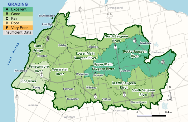
 Overall grades range from A (Excellent) to C (Fair), with mostly (60%) B (Good) grades. Most overall grades have not changed from the 2018 report card, however the Beatty Saugeen River, Lake Fringe and Upper Main Saugeen River areas have improved. Phosphorus grades fell in the South Saugeen River and Lower Main Saugeen River.  Remaining grades stayed the same. E.coli grades remained mostly unchanged across the watershed, with improvement for the Penetangore River area. Benthic macroinvertebrate grades generally improved.

Note:
  1. Streams and rivers are constantly changing, and water quality results represent only a snapshot in time.
Learn about surface water quality:
  1. Map: Provincial (Stream) Water Quality Monitoring Network | ontario.ca 
Subscribe to page updates

Contact Us

Saugeen Valley Conservation Authority footer logo

1078 Bruce Rd. 12
Box 150
Formosa, Ontario
N0G 1W0

Phone: (519) 364-1255
Send an Email

  • Follow Us

    • Facebook
    • Twitter
    • Instagram
  • Links

    • Accessibility
    • Freedom of Information
    • Privacy Statement
    • Sitemap
    • Website Feedback
    • Contact Us

© Copyright 2021 Saugeen Valley Conservation Authority

Designed by eSolutionsGroup

Browser Compatibility Notification

It appears you are trying to access this site using an outdated browser. As a result, parts of the site may not function properly for you. We recommend updating your browser to its most recent version at your earliest convenience.