
Water and Climate Data
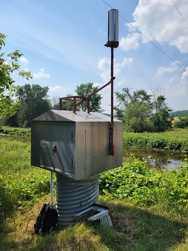
SVCA owns, operates, and maintains a hydrometric monitoring network, consisting of stream gauges and meteorological stations located throughout watershed. While some stream gauging stations measure only water level and discharge, many are equipped with additional sensors to measure the following parameters:
- Water level
- Precipitation
- Air and water temperature
- Wind speed and direction
Most of our stations are equipped with telemetry, which means that the data is automatically transmitted on an hourly basis, allowing for near real-time monitoring of current watershed conditions.
If you would like to request current or historical hydrometric data, please contact the Flood Forecasting and Warning Coordinator. Costs may apply for data products.
Collaborative Water Data Viewer
Saugeen Valley Conservation Authority (SVCA) is pleased to announce that real-time data from its hydrometric monitoring network is now available online through the Collaborative Water Data Viewer (CWDV). This open-data platform allows municipalities, stakeholders, and the public to explore up-to-date watershed information directly from SVCA’s monitoring stations.
SVCA has been sharing historic rainfall and snow data, updated on a biannual basis, since 2023. The CWDV updates hourly, as new data becomes available from SVCA’s hydrometric network, providing users with near real-time information. The CWDV also provides access to additional historic and current data, not previously available, including water level, streamflow, air temperature, water temperature, and soil moisture.
Data from SVCA’s hydrometric network is collected and managed through the Water Information System by Kisters (WISKI). Through a long-standing cost-sharing partnership with 10 other Conservation Authorities in the Western Ontario Data Hub, hosted by Upper Thames River Conservation Authority, SVCA now makes this information available at no cost to users.
To view the Collaborative Water Data Viewer which displays water level, stream flow, rainfall and snow data for 185 stations across several Conservation Authorities, dating back as far as 1914 for some stations, please click here.
SVCA Data Dashboard
RBC Tech for Nature funding enabled Saugeen Conservation to procure a data visualization tool and support for compiling data to provide the public with free access to the wealth of environmental data collected by SVCA. For decades, SVCA has been gathering surface water, snow survey, and watercourse data throughout the watershed.
Through partnership with the RBC Foundation, SVCA has made this data available in an AODA compliant format, to support community groups, environmental organizations, local governments, universities, and other stakeholders in their pursuit of watershed education and climate change initiatives. This information is updated twice annually.
For more information about the Tech for Nature program, please visit: www.RBC.com/techfornature
To view SVCA rain data over 12 locations throughout the watershed, dating back to 1984, please click here.
To view SVCA snow data over 14 locations throughout the watershed, dating back to 1960, please click here.
To view SVCA surface water quality data over 29 locations throughout the watershed, back to 2003, please click here.
Meteorological Stations
SVCA operates two meteorological stations that have been located to allow for monitoring of weather systems as they move through the watershed. The detailed information collected by these meteorological stations is used to assess flood potential in the watershed.
Protect your local environment
Consider a donation to conversation.