
- The route cuts across agricultural land. The heavy, mixed forest along the riverbanks blocks most farms from view.
- The route begins at Hanover Park in the town of Hanover.
- It ends 102 km downstream at Denny's Dam near Southampton.
Canoeing and Kayaking
Canoeing/Kayaking
The Saugeen River starts in one of the highest points in Southwestern Ontario. It flows through scenic countryside to Lake Huron at Southampton.
-
River conditions vary from broad calm sections to sections with rapids and eddies.
-
This makes the Saugeen River ideal for family canoeing, and will help you learn the basics of rapid water navigation.
-
The rapids present little difficulty, except in early spring.In spring, the water is high and fast flowing.
- Portages are short and bypass three dams.
- In late summer (if the water is low) some shallow stretches may make navigation difficult.
- Many access points and parks provide various facilities along the canoe route.
- You will see a variety of wildlife along the route. Some of these include great blue herons, mallards, beavers and muskrats.
- Sport fishing opportunities are good for bass, pike, rainbow and brown trout. Check our Fishing page for more information.
-
Weather and other natural processes can affect canoeing conditions. This means canoeing conditions are always changing.
-
This web page contains general information. It is not a detailed guide of conditions you may encounter.
-
Please remember canoeing can be a dangerous activity. Be sure to take precautions when planning your trip. Make sure you wear life preservers for any boating activity.
-
Visit the Operating a human-powered craft site for information on what you need on your trip.
The Route
-
The Saugeen River is the third largest river system in Southern Ontario. It is approximately 198 km long. From the headwaters in the Dundalk area to the town of Southampton, it falls a total of 1,158 feet. The river empties into Lake Huron.
-
The Saugeen River is one of the most popular canoe routes in Southern Ontario. There are many locations where you can put in and canoe or kayak for the day.
- The route begins at Access Point 3 in Hanover.
- Check out Bruce County's Canoe Route Map with individual maps of each access point with links to maps and GPS coordinates. It also provides the time and distance between access points and the level of paddling difficulty.
*The times listed below are typical for late May. Actual times will vary according to water conditions and the canoeist's ability. The length of any outing can be flexible, due to road and public access along the route.
Saugeen River Main Access Point Map
-
You can find Bruce County's Saugeen River Access Point Map on their website.
Portages along the Saugeen River Route
-
Maple Hill Dam - portage is on the left (south) bank, right upstream of the bridge.
-
Hydro Dam - the dam is 50 m downstream of the bridge.
-
Walkerton Dam - portage is 30 m above the dam on the left (west bank). Portage sign posted on far left (west bank).
-
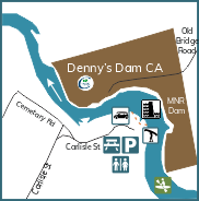
Denny's Dam - dock and steps located on left (south bank) on the Ministry of Natural Resources and Forestry (MNRF) side.
Popular Routes on the Saugeen River
-
Expert Portaging - distance 20 km - 4 hours - from Access Point 3-5 (see below) - challenging to expert
-
Walkerton to McBeath - distance 42 km - 12 hours - from Access Point 5 to 9 - challenging to expert
-
Paisley to Saugeen Bluffs - distance 8.5 km - 2 hours - Access Point 9 to 11 - easy to moderate
-
Saugeen Bluffs to Burgoyne - distance 9.5 km - 3 hours - Access Point 11 to 13 - beginner to moderate
-
Burgoyne Bridge to Denny's Dam - 15 km - 4 hours - Access Point 13 to 15 - beginner to intermediate
-
Denny's Dam to Southampton - 3 km - 2 hours - Access Points 15-16 - beginner to intermediate
Access Points on the Saugeen River
Please head to Bruce County's River Access Points information page! They will give you time and distance between each access point, amenities, GPS coordinates and a map.
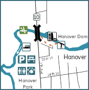
Access Point 3 - Hanover Town Park
- This is an exciting trek!
-
This access point is located in Hanover Town Park.
-
There are many amenities available at this access point including a playground, washroom, picnic shelter, band shell and a skateboard park.
-
The downtown core is a short walk away where there are many restaurants and stores.
-
Time to Access Point 4 is about 1 hour.
- Distance to get to Access Point 4 is about 5 km.
- Level is challenging to expert.
-
GPS 44.16231,-81.03666
-
Address: 742 7th Ave, Hanover, Ontario.
-
This access point is maintained by the Town of Hanover.
- Map this location.
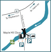
Access Point 4 - Maple Hill Dam
- This access point is located at Maple Hill Dam.
-
GPS 44.14359,-81.06667
-
There is a portage a short ride down the river.
-
There is great parking here but no amenities.
-
Time to Access Point 5 is 3 hours.
-
Distance to Access Point 5 is about 14.5 km.
-
Level is challenging to expert.
-
Address is: 161 Maple Hill Rd and 168 Maple Hill Rd, Walkerton, ON.
-
This access point is maintained by the Municipality of Brockton.
- Map this location.
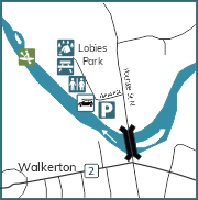
Access Point 5 - Lobies Park - Walkerton
- This access point is located at Lobies Park in Walkerton.
-
There is camping, a playground, lots of parking and great washrooms.
-
GPS 44.13707,-81.14583
- Time to Access Point 6 is about 3 hours.
- Distance to Access Point 6 is about 14.5 km.
- Level is challenging to expert.
- Address is: 20 Hannah Street, Walkerton, ON
- Walk to downtown is only minutes away where there are stores and restaurants.
- This is a great place to stop along the river or start your adventure.
- This access point is maintained by the Municipality of Brockton.
- Map this location.
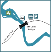
Access Point 6 - Brant Concession 8 Bridge
- This access point is located on popular Concession 8, 10 minutes from Walkerton.
- This is a busy road but is a great place to launch if you have a big group.
- There are 2 parking lots at this access point.
- This access point is about a 10-minute drive from Walkerton, where there are many restaurants and shops.
- GPS 44.20598,-81.19455
- Time to Access Point 7 is about 2 hours.
- Distance to Access Point 7 is about 6.5 km.
- Level is challenging to expert.
-
Address is: 1162 Concession 8, Walkerton, ON
- This access point is maintained by the Municipality of Brockton.
- Map this location.
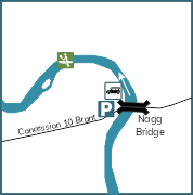
Access Point 7 - Brant Concession 10 Bridge
- This access point is located on a dirt road under a new bridge in Brant Township.
- This is a nice place to stop and stretch your legs and a calm place to launch.
- GPS 44.22678,-81.16633
- Time to Access Point 8 is about 3 hours.
- Distance to Access Point 8 is about 8.5 km.
- Level is challenging to expert.
- Address is: 846 Concession 10, Brant, Walkerton, ON
- This access point is maintained by the County of Bruce.
- Map this location.
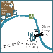
Access Point 8 - Brant Elderslie Line (McCurdy Bridge)
- This can be a very popular spot in summer.
- There are 2 places to launch on either side of the old bridge.
- Not many amenities but lots of friendly paddlers.
- GPS 44.26969,-81.21647
- Time to Access Point 9 is about 3 hours.
- Distance to Access Point 9 is about 10.5 km.
- Level is challenging to expert.
- Address is: 428 Brant-Elderslie, Walkerton Area, ON
- This access point is maintained by the County of Bruce.
- Map this location.
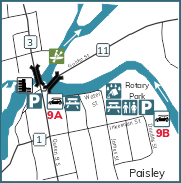
Access Point 9a and 9b - Paisley (9a at Rotary Park and 9b on Water Street)
- 9a-just off main street of Paisley - GPS 44.30663,-81.27216
- 9b-right in downtown Paisley - GPS 44.30591,-81.26444
- Both have docks for an easy launch.
- Parking is only on the roadside and you can’t leave cars there.
- Time to Access Point 10 is about 1 hour.
- Distance to Access Point 10 is about 2.5 km.
- Level is easy to moderate.
- Address is: 438 Inkerman Street, Paisley, ON
- This access point is maintained by the Municipality of Arran-Elderslie.
- Map this location.
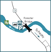
Access Point 10 - Bruce Road 3 - North of Paisley
- This access point is located just outside Paisley.
- It is a popular entry point for paddlers, and a popular location for fishing.
- There is lots of parking available to leave your car.
- GPS 44.32182,-81.28107
- Time to Access Point 11 is about 1 hour.
- Distance to Access Point 11 is about 2.5 km.
- Level is easy to moderate.
- Take a short walk back towards Paisley and you will find great places to have lunch.
- Address is: 3501 Bruce Road 3, Paisley, ON.
- This access point is maintained by the County of Bruce.
- Map this location.
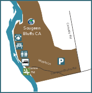
Access Point 11 - Saugeen Bluffs Conservation Area
- This access point is located in Saugeen Bluffs Conservation Area.
- Saugeen Bluffs is a popular campground located outside Paisley.
- There are campsites along the river, washrooms and a camp store. Call ahead to book your site for the night.
- It's a beautiful location to stop and stretch your legs.
- GPS 44.34936,-81.31475
- Time to Access Point 12 is about 1 hour.
- Distance to Access Point 12 is about 3 km
- Level is beginner to intermediate.
-
Address is 132 Saugeen Bluffs Road, Saugeen Shores, ON.
- This access point is maintained by the Saugeen Valley Conservation Authority.
- Map this location.
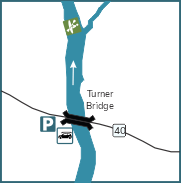
Access Point 12 - Bruce Road 40 Bridge (Turners)
- This access point is located just under Bruce Rd 40 bridge.
- Perfect spot to launch.
- Large parking lot leaves room to leave cars or drop your canoe off.
- GPS 44.36839,-81.31630
- Time to Access Point 13 is about 2 hours.
- Distance to Access Point 13 is about 8.5 km.
- Level is beginner to intermediate.
- Address is: 1813 Bruce Rd 40, Paisley, Ontario.
- This access point is maintained by the County of Bruce.
- Map this location.
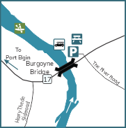
Access Point 13 - Bruce Road 17 - West of Burgoyne
- One of the most popular places to launch on the Saugeen River in the summer.
- Good place to park at the start or end of your trip.
- This stop is located in the beautiful Bruce County countryside.
- GPS 44.41892,-81.35338
- Time to Access Point 14 is about 2 hours.
- Distance to Access Point 14 is about 7.5 km.
- Level is beginner to intermediate.
- Address is: 854 Bruce Road 17, Port Elgin, Ontario.
- This access point is maintained by the County of Bruce.
- Map this location.
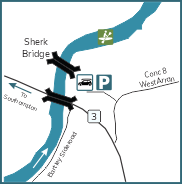
Access Point 14 - Bruce Road 3 - (Scherk Bridge)
- This access point is located at old Sherk Bridge.
- There’s plenty of parking and it is a popular place to fish off of the old bridge.
- Nice spot to stop and stretch your legs.
- GPS 44.45863,-81.32523
- Time to Access Point 15 is about 2 hours.
- Distance to Access Point 15 is about 7.5 km.
- Level is beginner to intermediate.
- Address is: 5058 Bruce Road 3, Southampton, Ontario.
- This access point is maintained by the County of Bruce.
- Map this location.
Access Point 15 - Denny's Dam Conservation Area - Carlisle Street
- This access point is located at Denny’s Dam.
- Great place to launch or end your trip on the Saugeen River.
- Plenty of parking and washroom facilities.
- GPS 44.51237,-81.32963
- Time to Access Point 16 is about 1 hour.
- Distance to Access Point 16 is about 6 km.
- Level is beginner to intermediate.
- Address is: 503 Carlisle Street, Southampton, Ontario.
- This access point is maintained by the Town of Saugeen Shores.
- Map this location.
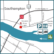
Acccess Point 16 - Chesley Street - Southampton
- The last access point on the Saugeen River is located in Southampton.
- There’s a large amount of parking and washroom facilities.
- After you get off the river, walk or take a drive to Southampton before you head home.
- GPS 44.5002,-81.36146
- Address is: 1 Chesley Street, Southampton, Ontario.
- This access point is maintained by the Town of Saugeen Shores.
- Map this location.
Other popular routes along the Saugeen River
Hanover to Southampton
- 102 km
- 21 to 27 hours
- 3-4 days
Hanover to Walkerton
- 20 km
- 5 hours
- There are three dams located along this section. These dams were once used for milling and hydro electric generation.
- From Hanover to the Maple Hill Dam, the water tends to be deep and slow moving. Downstream there are several gentle rapids.
- This section of the route tends to be the most wooded.
Walkerton to Paisley
- 39 km
- 7-10 hours
- Many high sand and clay bluffs border the river downstream of Walkerton. These provide homes for swallows and kingfishers.
- You should exercise caution in portions of this section. There are many rapids, large rocks and flood debris here.
- This is the most challenging section of the route.
- The forest cover gives way to rolling pastureland in the downstream part of this section.
Paisley to Southampton
- 43 km
- 9-12 hours
- Several gentle rapids occur between Paisley and Southampton.
- Near Saugeen Bluffs Conservation Area, the river has a border of clay bluffs. These form the edge of a well-defined floodplain.
- The river has sandy, treed islands. These are the remnants of a former delta further downstream.
More information on canoeing and kayaking:
- Saugeen River Canoe Route (Bruce County Tourism site).
- Saugeen River Canoe Route Map (a map of the complete route with access point maps).
- Youtube video of the canoe route from Lobies Park in Walkerton to McBeath Conservation Area.
- Youtube video of the canoe route from McBeath Conservation Area to Southampton.
- A Google search will help you find outfitters with rentals of canoes and equipment in the area.
SVCA has two properties where camping is offered along the Saugeen River route:
- Saugeen Bluffs Conservation Area (between Paisley and Southampton)
- McBeath Conservation Area (upstream from the Village of Paisley)
Protect your local environment
Consider a donation to conversation.