Skip to Content
Camping ReservationsCareersContact UsDonate Now

Saugeen Valley Conservation Authority Logo

Contact Us
  • Outdoors and Recreation
    View our Outdoors and Recreation page
    • Camping
      • Durham Winter Camping
      • Reserve a Campsite
      • Group Camping
      • Firewood
      • Rules and Regulations
    • Activities and Recreation
      • Canoeing and Kayaking
      • Day Use Fees
      • Durham Disc Golf
      • Fishing
      • Hunting
      • Rent a Facility
      • Trails and Hiking
      • Saugeen Bluffs Events
      • Winter Camping at Durham CA
    • Outdoor Spaces
      • Allan Park
      • Bell's Lake
      • Brucedale
      • Denny's Dam
      • Durham
      • Hardwood Hill
      • Kinghurst
      • McBeath
      • Mildmay-Carrick
      • Saugeen Bluffs
      • Schmidt Lake
      • Stoney Island
      • Sulphur Spring
      • Varney
  • Permits and
    Planning
    View our Permits and Planning page
    • Appeal Process
    • Applying for a Permit
    • Book a Planning Act Pre-Submission Consultation
    • Environmental Regulations
    • Maps and GIS
    • Agreements
    • Planning and Regulations FAQ
    • Planning Services
    • Report a Concern
  • Forestry and
    Landowner Services
    View our Forestry and Landowner Services page
    • Forestry and Land Management
    • Stewardship Projects and Services
    • Tree Planting and Sales
  • Water Management
    and Protection
    View our Water Management and Protection page
    • Drinking Water Source Protection
    • Flood Forecasting and Warning
    • Frequently Asked Questions
    • Water Quality Monitoring
    • Water Well Improvement Program
    • Watershed Report Cards
    • Water and Climate Data
    • Water and Erosion Control Infrastructure
  • About
    Us
    View our About Us page
    • Accessibility and Customer Service Standards
    • Board of Directors
    • Careers
    • Committees
    • Contact Us
    • Delegation Request
    • Donate Now
    • Explore SVCA Program
    • Freedom of Information
    • Governance
    • Hours and Location
    • Meeting Calendar
    • Meeting Summaries
    • News and Notices
    • Subscribe
    • Tenders and RFPs
x

Groundwater Quality

  • Facebook
  • Twitter
  • LinkedIn
  • Email

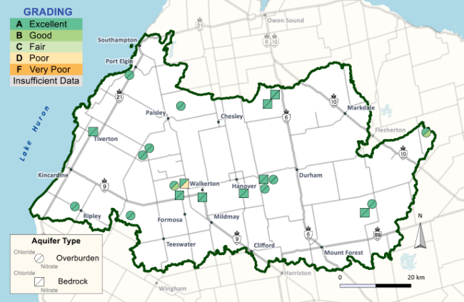
Groundwater is flowing water that is found below the ground, that is often stored in aquifers.  Groundwater is monitored at 23 sites in our watershed through the Provincial Groundwater Monitoring Network (PGMN). Groundwater quality for this report was graded on chloride and nitrogen (nitrate + nitrite) levels. 

Chloride and nitrogen can exist naturally, however natural levels in water are generally minimal. Increased levels in our waterways can be related to:

  • the use of road salts (chloride only)
  • septic systems
  • fertilizers and manure
  • industrial discharge
  • erosion
What's different in this report card?

Previous watershed report cards only used five years of data to come up with their findings.  This report card uses a minimum of ten years of data, or more if it was available for a better view of long term trends.

Our Findings:
  • Chloride levels at all tested sites received a grade of A (excellent).
  • Nitrogen levels at most (86%) of the sites received a grade of A (excellent).
  • Two sites received nitrogen grades of B (good) and one site received a D (poor).

Different nitrogen grades from these sites could be caused by using more data from a longer period of time. The three sites that did not receive an A grade are in locations where we might expect to see higher levels of nitrogen, based on their environments.

Chloride levels at all tested sites received a grade of A (excellent). Nitrogen levels at most (86%) of the sites received a grade of A (excellent). Two sites received nitrogen grades of B (good) and one site received a D (poor).

Note:
  1. These findings are not to be considered indicators of drinking water quality.
  2. Groundwater quality results being reported are specific to the site location and do not apply to the watershed as a whole.
  3. No biological levels (ie. E.coli) were considered.
Learn about groundwater:
  1. Ontario Groundwater Association

  2. Public Health Grey Bruce

Subscribe to page updates

Contact Us

Saugeen Valley Conservation Authority footer logo

1078 Bruce Rd. 12
Box 150
Formosa, Ontario
N0G 1W0

Phone: (519) 364-1255
Send an Email

  • Follow Us

    • Facebook
    • Twitter
    • Instagram
  • Links

    • Accessibility
    • Freedom of Information
    • Privacy Statement
    • Sitemap
    • Website Feedback
    • Contact Us

© Copyright 2021 Saugeen Valley Conservation Authority

Designed by eSolutionsGroup

Browser Compatibility Notification

It appears you are trying to access this site using an outdated browser. As a result, parts of the site may not function properly for you. We recommend updating your browser to its most recent version at your earliest convenience.